Physical Geography of India (Himalayas, Northern Plains)
- India has vast diversity in physical features.
- This diversity of landmass is the result of the large landmass of India formed during different geological periods and also due to various geological and geomorphological process that took place in the crust.
- According to Plate Tectonic theory folding, faulting and volcanic activity are the major processes involved in the creation of physical features of Indian landscape. For example, the formation of the Himalayas in the north of the country attributed to the convergence of Gondwana land with the Eurasian plate.
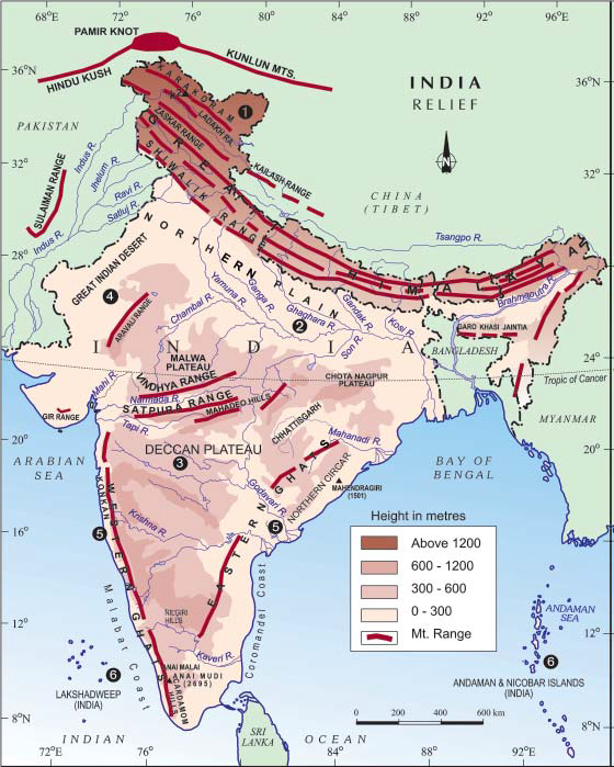
- The Northern part of the country has a vast expanse of rugged topography consisting of a series of mountain ranges with varied peaks, beautiful valleys and deep gorges.
- The Southern part of the country consists of stable table land with highly dissected plateaus, denuded rocks and developed series of scarps.
- The Great Northern Plains lies between these two landscapes.
- The physical features of India can be grouped under the following Physiographic Divisions:
- The Himalayas
- The Northern Plains
- The Peninsular Plateau
- The Indian desert
- The Coastal Plains
- The Islands
(Figure: various physical features of India)
Source- NCERT
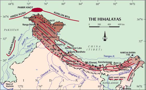
The Himalayas
- The Himalayas are young fold mountains which form the northern boundary for the country.
- The Himalayas is divided based on two lines: one is longitudinal divisions and the other is from west to east.
- The Himalayas consists of series of parallel mountain ranges.
- The Himalayas form an arc, which covers a distance of about 2400 km and the width varies from 400 km in the west to 150 km in the east.
- The altitudinal variations are greater in the eastern part than in the western part.
- On the basis of longitudinal extent, the Himalayas consists of three parallel ridges: The Greater Himalayas or Inner Himalayas or Himadri; Himachal or lesser Himalaya and the outer or Shiwalik Himalayas.
- The Greater Himalayas are the most continuous ranges consisting of the loftiest peaks with an average height of 6000m.
- The folds of Great Himalayas are asymmetrical in nature.
- The core part of this Himalayas consists of granites.
- The general orientation of these ranges is from northwest to southeast direction in north-western part; the east-west direction in Darjeeling and Sikkim Himalayas and southwest to northeast in Arunachal Region.
- The Himachal or lesser Himalayas mainly composed of highly compressed and altered rocks.
- The longest range of this system is Pir Panjal Range.
- This range consists of famous valley of Kashmir, the Kangra and the Kullu Valley.
- The Outer most range of the Himalayas is called the Shiwaliks. They composed of unconsolidated sediments brought down by rivers from the main Himalayan range located farther north.
- The Longitudinal valley lying between lesser Himalayas and Shiwaliks are known as Duns. Example: Dehra Dun, Kotli Dun, Patli Dun.
- The highest peak of Himalayas is:Everest, Nepal (8848 m); Kanchenjunga, India (8598 m); Makalu, Nepal (8481 m)
- On the basis of relief, alignment of ranges and other geomorphological features the Himalayas can be sub-divided into following
- North-western or Kashmir Himalayas
- Himachal and Uttarakhand Himalayas
- Darjeeling and Sikkim Himalayas
- Arunachal Himalayas
- Eastern Hills and Mountains
Source- NCERT
North-Western or Kashmir Himalayas
- Important Ranges: Karakoram, Ladakh, Zaskar and Pir Panjal
- Important Glaciers: Siachen, Baltoro, Remo, etc.,
- Imporatant Pass: Zoji la, Bara Lacha la, Banihal, rohtang, etc.,
- Important Peaks: Nanga Parbat, K2, etc.,
- Kashmir valley: lies between Greater Himalayas and Pir Panjal Range.
- Cold Desert: between Greater Himalayas and Karakoram Range.
- Important Lakes: Dal and Wular are freshwater lakes, whereas Pangong Tso and Tso Moriri are saltwater lakes.
- The Southernmost part of this region consists of longitudinal valleys known as Duns. Eg: Jammu dun, Pathankot dun, etc.,
Himachal and Uttarakhand Himalayas
- Important Ranges: Great Himalayas, Dhaoladhar, Shiwaliks, Nagtibha, etc.,
- Important River System: Indus and Ganga
- Important Hill Stations: Dharmashala, Mussoorie, Shimla, kaosani, etc.,
- Important Pass: Shipki la, Lipu Lekh, Mana pass, etc.,
- Important Glaciers: Gangotri, Yamunotri, Pindari, etc.,
- Important Peaks: Nanda Devi, Dhaulagiri, etc.,
- Important Duns: Dehra Dun (largest), Harike Dun, Kota Dun, Nalagarh Dun, Chandigarh-Kalka Dun, etc.,
- This region is known for five Prayags (River Confluences). Valley of flowers is also situated in this region.
The Darjeeling and Sikkim Himalayas
- This lies between Nepal Himalayas in the west and Bhutan Himalayas in the east.
- It is the region of fast flowing rivers and high mountain peaks.
- Important Peaks: Kanchenjunga
- Duar formations replace the Shiwaliks (absent) in this region which enhanced the development of Tea gardens.
- Important Glaciers: Zemu Glacier
- Important Peaks: Nathu La and Jelep La
The Arunachal Himalayas
- This lies between Bhutan Himalayas and Diphu Pass in the east
- Important Peaks: Namcha Barwa and Kangto
- Important Rivers: Subansri, Dihang, Dibang and Lohit
- Important Ranges: Mishmi, Abor, Dafla, Mihir, etc.,
- Important pass: Diphu pass
The Eastern Hills and Mountains
- These are the part of Himalayan Mountain system having their general alignment from the north to south direction.
- The Himalaya in the eastern boundary of the country is called as Purvanchal. These are mainly composed of sandstones (sedimentary rocks).
- Important Hills: Patkai Bum, Naga Hills, Manipur Hills, Mizo hills, etc.
THE NORTHERN PLAINS
- The northern plain has been formed by the interplay of the three major river systems – the Indus, the Ganga and the Brahmaputra.
- This plain is formed of Alluvial Soil – the deposition of alluvium in a vast basin lying at the foothills of the Himalayas over millions of years.
- It is the densely populated and agriculturally very productive physiographic division of the country.
- According to the variations in the relief features, the northern plain can be divided into four regions (from north to south) – Bhabar, Terai, Bhangar and Khadar.
- Bhabar is a narrow belt ranging between 8-10 km parallel to the Shiwalik foothills at the break-up of the slope. The river after descending from the mountains deposit pebbles in a narrow belt. All the streams disappear in this belt.
- In the Terai region, south of Bhabar belt the streams and rivers re-emerge and create a wet, swampy and marshy region, characterised with thickly forested region full of wildlife
- Bhangar is the region lies south of Terai region. This region is formed by older alluvium. The soil in this region contains calcareous deposits locally known as kankar.
- The region with new alluvium deposits is known as Khadar. They are renewed almost every year and are so fertile, thus ideal for intensive cultivation.
- Riverine Islands – these are the islands which are formed due to depositional work of rivers especially in the lower course due to the gentle slope and resultant decrease in the velocity of rivers. Majuli – in the Brahmaputra is the largest inhabited riverine island in the world
- Distributaries – the rivers in the lower course split into numerous channels sue to deposition of silt are called distributaries.
- Doab – the area which lies behind the confluence of two rivers.
Major Mountain Peaks in India
| Description |
| Godwin Austen (K2) | Highest peak of Karakoram range in POK |
| Nanga Parbat | Jammu and Kashmir |
| Nanda Devi | Uttarakhand, Second highest mountain in India and the highest entirely within the country |
| Kanchenjunga | Nepal and Sikkim (B/w Teesta river in east & Tamur river in the west), the Highest mountain in India & 3rd highest mountain in the world |
| Nokrek | Highest point of the Garo Hills (Meghalaya) |
| Gurushikhar | Mt. Abu, Rajasthan, highest point of the Aravalli Range |
| Kundremukh | Karnataka |
| Doddabetta | Highest point in Tamil Nadu, near Udhagamandalam (Nilgiri Hills) Second highest peak in the Western Ghats only next to Anamudi |
| Anaimudi | Located in Kerala, It is the highest peak in the Western Ghats and in South India |
| Agasthyamalai | Lie at the extreme southern end of Western Ghats, straddle both sides in Kerala and in Tamil Nadu |
| Saddle Peak | Highest point of the archipelago in the Bay of Bengal, located in North Andaman |
| Mount Hariet | Third highest peak in the Andaman and Nicobar archipelago only next to, Saddle peak (Highest of Andaman) and Mount Thullier (Highest of Nicobar) |
| Mahendragiri | Orissa, the Highest peak of Eastern Ghats (According to NCERT) |
| Arma Konda | Andhra Pradesh |
Important Passes in India
| State | Pass name | Comment |
| Jammu and Kashmir | Banihal Pass | Jammu to Srinagar |
| Jammu and Kashmir | Chang-La | Ladakh with Tibet |
| Jammu and Kashmir | Pir-Panjal pass | Between Jammu and Kashmir Valley |
| Jammu and Kashmir | Zoji La | important road link between Srinagar on one side and Kargil and Leh on the other side |
| Himachal Pradesh | Bara Lacha La | Connecting Mandi in Himachal Pradesh with Leh in Jammu and Kashmir |
| Himachal Pradesh | Rohtang Pass | road link between Kullu, Lahaul and Spiti Valleys |
| Himachal Pradesh | Shipki La | Himachal Pradesh and Tibet |
| Uttarakhand | Lipu Lekh | trijunction of Uttarakhand (India), Tibet (China) and Nepal borders |
| Uttarakhand | Niti Pass | Uttarakhand with Tibet |
| Sikkim | Nathu La | Sikkim with Tibet |
| Sikkim | Jelep La | Sikkim-Bhutan border |
| Arunachal Pradesh | Bom Di La | Arunachal Pradesh with Bhutan |
| Arunachal Pradesh | Dihang Pass | Arunachal Pradesh and Myanmar |
Comments
Post a Comment